If you’re planning a road trip through the Northwoods or across the I-39 corridor this week, you might want to check your speedometer and keep your eyes on the road. The Wisconsin State Patrol aerial enforcement missions are officially back on the calendar for the final week of May 2026. While most drivers are scanning the ditches for squad cars, the real surveillance is happening at 1,500 feet. The Air Support Unit Wisconsin is deploying its fleet to crack down on speeding violations and aggressive driving, and they’ve released a specific schedule to encourage "voluntary compliance."
Full Aerial Enforcement Schedule: May 26 – May 31, 2026
The aerial traffic enforcement schedule for this week targets high-traffic corridors and known danger zones. If you are traveling through Portage, Oneida, or Door counties, the "eye in the sky" will be active. Note that all missions are weather permitting; if visibility is low or there’s heavy rain, the planes stay grounded.
| Date | Highway/Interstate | County |
|---|---|---|
| Tuesday, May 26 | Interstate 39 (I-39) | Portage and Waushara |
| Wednesday, May 27 | Interstate 94 (I-94) | Jefferson |
| Thursday, May 28 | I-43 and I-94 | Manitowoc and Eau Claire |
| Friday, May 29 | US Highway 51 | Oneida |
| Sunday, May 31 | Wisconsin 57 (WIS 57) | Door |
This Wisconsin State Patrol aerial enforcement schedule is part of a broader public safety mission to reduce traffic violations during the heavy Memorial Day travel window. By announcing these zones in advance, the Wisconsin Department of Transportation (WisDOT) aims to slow down traffic before a single ticket is even written.
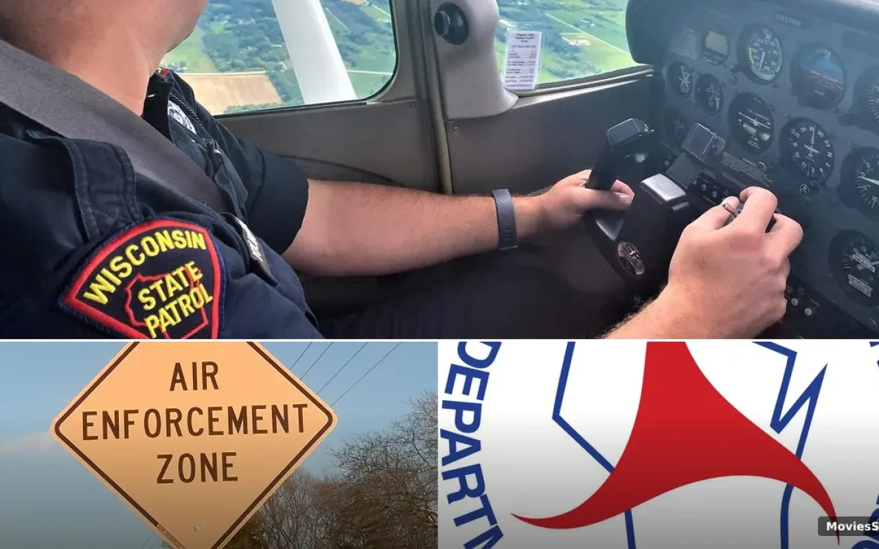
How Does Wisconsin’s Air Support Unit Actually Catch You?
The wild part about Wisconsin speeding enforcement from the air is that it doesn’t use traditional radar. If you have a radar detector, it won't save you here. The state patrol pilots use a system called VASCAR technology (Visual Average Speed Computer and Recorder).
Here’s the technical breakdown of how aerial speed timing works:
- The Lines: Have you ever noticed those white horizontal lines painted across the highway every quarter-mile? Those aren’t for road construction. They are timing marks.
- The Math: A pilot in a Wisconsin State Patrol plane model (typically a Cessna 172 or 182) uses a high-precision stopwatch to time how long it takes your vehicle to travel between those marks.
- The Communication: Once the VASCAR computer calculates that you’re flying low, the pilot radios ground-based troopers stationed a few miles ahead.
- The Stop: The pilot maintains aerial surveillance on your vehicle until the ground unit initiates the traffic stops, ensuring there is no "identity crisis" regarding which car was speeding.
Real talk: Pilots aren’t just looking for speed. They are trained to spot aggressive driving behaviors like tailgating, illegal lane changes, and distracted driving that are often invisible to a trooper sitting in a median crossover.
Portage, Oneida, and Door County Focus
The I-39 traffic enforcement in Portage County is a high-priority zone this week. This stretch of highway is notorious for heavy merging traffic and high speeds. Meanwhile, the highway 51 aerial patrol in Oneida County on Friday is timed perfectly for the influx of weekend travelers heading to their cabins.
In Door County, the focus shifts to WIS 57 on Sunday. This is a critical highway safety initiative because of the unique mix of local traffic, tourists, and boat trailers. With the "Drive Safe. Tow Safe. Boat Safe." campaign in full swing, officials are particularly sensitive to those towing heavy loads, as stopping distances increase significantly.
The Legal Reality: Can You Fight an Aerial Ticket?
One of the biggest questions drivers ask is: "Is it legal for a plane to clock my speed?" The answer is a resounding yes, but it does create a unique situation in court. Because the pilot is the one who technically witnessed the violation, they are the "witnessing officer."
Under the Sixth Amendment, you have the right to confront your accuser. In many Wisconsin State Patrol aerial enforcement cases, if you challenge the ticket, the pilot may actually have to appear in court or provide a certified log of the VASCAR calibration. However, because the Air Support Unit keeps meticulous records and the Cessna 182 aircraft are maintained to FAA standards, these citations are notoriously difficult to beat.
Why the Eye in the Sky is More Efficient
You might wonder why the state spends money on fuel and pilots instead of just putting more squads on the road. The data shows that aerial traffic enforcement is actually highly cost-effective for highway safety. A single pilot can monitor a five-mile stretch of highway and coordinate five or six ground-based troopers simultaneously.
According to State Patrol Superintendent Tim Carnahan, the goal isn't to "trap" people but to foster voluntary compliance. When drivers know there is a plane overhead, the collective speed of the entire highway drops. This reduces the "speed differential" between cars, which is a leading cause of multi-vehicle summer crashes.
Key Takeaways for Wisconsin Drivers
- Check the Skies: If you see a white Cessna circling a specific stretch of I-39 or US 51, aerial traffic enforcement is likely active.
- Weather Matters: These patrols are weather permitting. High winds or low cloud ceilings (under 1,000 feet) will usually cancel the mission.
- Watch the Lines: Those white pavement markings are your cue that you are in a VASCAR timing zone.
- Safety First: The "Drive Safe. Tow Safe. Boat Safe." campaign means troopers are looking for more than just speed—secure your trailers and put the phone down.
As we head into the peak of the summer travel season, the Wisconsin State Patrol is making it clear: they are watching from every angle. Whether it's a trooper in a cruiser or a pilot in a Cessna, the mission remains the same—getting everyone home in one piece. Drive like someone is watching, because this week, they definitely are.